Antique Map Connecticutt New York 1912


$18.00
Quantity available: 1
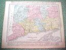
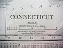
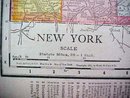
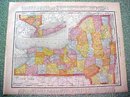
Offering this nice old 1912 map of the state of Connecticutt on one side and New York on the other side. This map was published / printed by Rand McNally & Co, 1912. Copyright 1911 on New York side of map, but it was acquired from the Rand McNally Atlas, published 1912 - this is not a reproduction. Measures 14 x 11 1/2 inches, good+ condition, no holes, tears, or stains( one tiny edge tear will not show when framed); light age toning that adds to its charm. Nice colors and details. These old maps look really great matted & framed. A handsome piece of history and unusual art piece for your home or office!
Great Expectations Antiques
Caldwell, Ohio
Dealer accepts: Cash, PayPal, Money Order, Check
Shipping: $6.80

