Antique Map Philadelphia New York City Brooklyn 1890


$35.00
Quantity available: 1
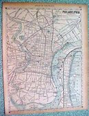
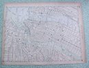
Offering this nice old 1890 map of the city Philadelphia (PA) on one side and the cities of New York, Brooklyn, Hoboken, Jersey City, and part of Long Island on the other side. This map was published / printed by Rand McNally & Co, 1890. No date is printed directly on the map but it was acquired from the Rand McNally Atlas, published 1890 - this is not a reproduction. Measures 13 3/4 x 10 1/2 inches, good+++ condition, no holes, tears, or stains; light age toning that adds to its charm. Nice colors and details. These old maps look really great matted & framed. A handsome piece of history and unusual art piece for your home or office!
Great Expectations Antiques
Caldwell, Ohio
Dealer accepts: PayPal, Money Order, Check, Cash
Shipping: $6.80

