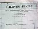
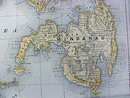
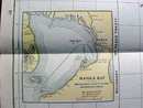
Antique Map Philippine Islands 1906 Large Fold Out


$42.50
Quantity available: 1
Offering this nice old large fold out map of the Philippine Islands, this map comes from the Peerless Twentieth Century Pictorial Gazetteer. This map was published / printed by Crowell Publishing Co, New York, 1906, copyright date on map is 1899 - this is an authentic map from 1906 - not a reproduction. Measures 21 1/2 inches tall x 13 1/2 inches wide, fine condition, no holes or tears. Wonderful colors and details. These old maps are excellent for framing. A handsome piece of history for your home or office!
Great Expectations Antiques
Caldwell, Ohio
Dealer accepts: Money Order, Cash, Check, PayPal
Shipping: $7.50


