Antique Map Spain Holland Belgium Denmark Crams 1883


$38.50
Quantity available: 1
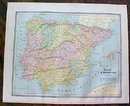
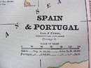
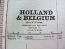
Offering this wonderful old 1883 Crams map of Spain & Portugal on one side and Holland, Belgium & Denmark on the other side. This map was engraved by George F Cram and printed by Henry S Stebbins, Chicago, 1883. These individual maps do not have the date on them but were part of Cram's Unrivaled Family Atlas, dated 1883. Measures 13 1/2" x 11 1/4" including blank margins. Good condition, no holes or tears, some spotting on blank margin of Holland side which will not show when framed. Very nicely detailed, great colors; mat and frame this handsome piece of history for your home or office or an antique gift!
Great Expectations Antiques
Caldwell, Ohio
Dealer accepts: Cash, Money Order, Check, PayPal
Shipping: $7.80

